

Articles
Interview: Lt Gen AK Bhatt (retd)
Sub Title : Frank and forthright interview with DG ISpA
Issues Details : Vol 19 Issue 3 Jul – Aug 2025
Author : Editorial Team
Page No. : 37
Category : Military Affairs
: July 29, 2025

Lt Gen AK Bhatt PVSM UYSM AVSM SM VSM (Retd) is the Director General of Indian Space Association (ISpA) and Chairman of Board of Governors at IIIT Kota & Ranchi. A decorated Army veteran with 39 years of service, he served in critical roles, including DG Military Operations during the Doklam crisis and Corps Commander of the Chinar Corps. An alumnus of the Army Staff College (UK), with advanced degrees in management and strategy, he now leads efforts to advance India’s private space sector.
India’s Spacepower in Op Sindoor and the Challenge of the China-Pak Axis
Lt Gen AK Bhatt (Retd), DG, Indian Space Association (ISpA)
This exclusive interview with the Director General of ISpA offers rare insights into India’s use of Space assets during Operation Sindoor, the growing China-Pakistan space nexus, and the urgent need to bolster indigenous capabilities in ISR, SATCOM, and navigation. A candid, in-depth account of space warfare’s emerging frontiers.
Defstrat: How would you characterise Pakistan’s space-based capabilities, particularly during Operation Sindoor? What was the extent of Chinese support?
DG ISpA: Pakistan’s space programme, to be candid, is still in a very nascent stage. However, during Operation Sindoor, it managed to gain an edge, but that advantage wasn’t organic. It came from sustained and sophisticated support from China. The Sino-Pak collusion seems to have helped Pakistan punch much above its weight, especially in terms of Situational awareness, communications, PNT and ISR.
A good example is PakSAT-MM1R, launched in May 2024 from China’s Xichang Satellite Launch Centre. On paper, it’s labelled a civilian communication satellite, but with nine antennas and 48 transponders spanning multiple bands, its payload is capable of supporting military-grade operations, including secure communications and encrypted data links for drone-based targeting support. Another key satellite is PRSS-1, also made in China. With a 1-meter optical imaging capability, it’s is suited for reconnaissance. Even PakTES-1A, while lower in resolution, proved useful for terrain mapping and operational planning.
All of these systems fall under SUPARCO, Pakistan’s Space agency, but in reality, the backbone is all Chinese assets. And it goes deeper.
Open-source intelligence suggests Pakistan may have received real-time ISR feeds from China’s Yaogan, Gaofan and Jilin satellite constellations. If true, that’s not just passive support, that’s direct enabler-level ISR, possibly even contributing live targeting data. That would have directly influenced Pakistan’s tactical decisions during the conflict.
Additionally, there’s the ground side. China operates satellite control stations near Islamabad, specifically under the China-Pakistan Space Cooperation Centre. These stations manage telemetry and data relay, and by all accounts, they’re tied into China’s broader surveillance net that covers this entire region. With that, Pakistan isn’t just using its own satellites, it’s essentially borrowing reach from China a space power with credible capabilities.
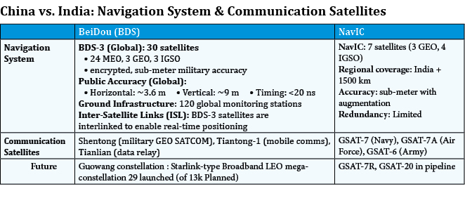
As regards Position Navigation and Timing (PNT)T is concerned, the Beidou constellation with 30 satellites in the GEO and MEO orbit augmented with 120 ground stations provides a resilient Navigation System to the Pak Armed Forces.
And then there is the symbolism. China’s recent move to train and fly a Pakistani astronaut to the Tiangong Space Station isn’t just a scientific gesture but a Geo-political indicator. It signals deep, long-term strategic alignment. that said, Pakistan remains heavily dependent on China
It doesn’t have its own launch capability, its payload design capacity is limited, and its technological ecosystem is fragile. So while China’s support gives it short-term teeth, it creates long-term dependencies.
What Operation Sindoor revealed is the maturing of the China-Pakistan space-military nexus, a development that India must treat with utmost seriousness.
This is a wake-up call. It reinforces the urgency for us to invest in indigenous EO satellites, advanced SATCOM, real-time ISR, and space resilience. Our regional edge will depend on it. Also, all military planners in India have to keep in mind that Chinese ISR capabilities, which are significant, are all available to Pakistan.
Defstrat: How were India’s space assets employed during Operation Sindoor? What were the key takeaways?
DG ISpA: Operation Sindoor gave us a real-world opportunity to test how far our space systems have come and how effectively they can support our armed forces in the middle of a high-stakes situation. We made extensive use of our indigenous space assets. The Cartosat-2C satellite provided sharp, high-resolution imagery for target verification and post-strike assessment. Meanwhile, RISAT satellites equipped with synthetic aperture radar enabled all-weather, day-and-night surveillance a game-changer given the cloud cover during certain phases.
To ensure continuity in ISR, we also sourced imagery from multiple and varied international commercial platforms like Maxar, ICEYE, Airbus and others. This filled in coverage gaps and ensured near-persistent monitoring, especially in fast-moving tactical environments.
On the communications front, GSAT-6, GSAT-7, and GSAT-7A ensured secure, service-specific real-time links across the Army, Navy, and Air Force. These were critical in coordinating synchronised strikes across multiple sectors.
Our indigenous NavIC system played a role in guiding standoff precision munitions. It enabled UAVs to execute cross-border strikes with surgical accuracy without violating airspace.
That said, NavIC isn’t without issues. The limited number of operational satellites must have affected coverage consistency. Also, the adoption of NavIC for all our vectors and usages has not really happened. Also, in the domain of space-based situational awareness and electronic warfare, we still have ground to cover.
Overall, the operation demonstrated that when our space architecture works in tandem with military strategy, the result is potent. We saw quick decision-making, smooth coordination, and precise execution. But it also reminded us where we need to invest next faster satellite rollouts, better navigation coverage, and more private-sector involvement in building our space resilience.
Defstrat: How effective were India’s ISR capabilities during the conflict? Why did much of the satellite imagery in public discourse originate from Maxar?
DG ISpA: India’s ISR capabilities today are far more advanced than they were even a decade ago. We’ve built a strong base electro-optical satellite like the Cartosat series, radar satellites such as RISAT, and platforms like EMISAT for signals intelligence. These assets, developed largely by ISRO and DRDO, have given our forces significant coverage across the subcontinent.
During Operation Sindoor, about 10 satellites were reportedly tasked in support roles, including Cartosats, RISATs, EMISAT, and NavIC-based assets. These provided real-time mapping,and strategic-level reconnaissance.
That said, at the operational and tactical level, there were limitations which surfaced.
- First, revisit rates. Even with multiple satellites, getting frequent and real-time coverage over a single hotspot can be tough. EO satellites don’t see through clouds, and while our SAR capabilities helped, we don’t yet have enough radar satellites in orbit to guarantee persistence.
- Second, there’s the issue of latency satellite images from ISRO or DRDO typically flow through government channels like DIPAC or NTRO. That process takes time, and in a fast-moving battlefield, minutes can make a difference. These are indications that the time was reduced significantly, but much more needs to be done.
Much of the satellite imagery used by media, think tanks, and even diplomats came from Maxar because our own data, while capable, remains tightly controlled and isn’t released easily.
So, in strategic terms, we had visibility. But in tactical terms, we need better integration faster tasking, inter-agency coordination, and direct data links to field units.
We must also invest in real-time relay constellations and expand our radar coverage. Indian start-ups like Pixxel, GalaxEye, Suhora,Kawa and Satsure are doing phenomenal work. Their inclusion will be vital in building a responsive, AI-fused ISR grid.
Defstrat: NavIC played a critical role in this conflict. But with only five satellites active, how reliable was it?
DG ISpA: Let me be very clear NavIC did play a role during Operation Sindoor. Despite a lean constellation, the system delivered critical positioning, navigation, and timing (PNT) services to the armed forces across multiple mission profiles. NavIC enabled high-precision targeting without relying on foreign GNSS systems.
Our strike platforms were able to hit terror camps with sub-meter accuracy without crossing the Line of Control a which is a direct testament to NavIC’s precision and reliability. But here’s the reality – we were on thin ice. As per a recent RTI, only four satellites were fully functional, and one (IRNSS-1F) was down to its last atomic clock. A failure there would’ve knocked NavIC below operational minimums. This isn’t a hypothetical risk, it is a real vulnerability. To plug this, we have begun deploying the NVS series, which feature indigenous rubidium clocks. However, NVS-02 suffered a propulsion malfunction and couldn’t deploy at the desired orbit, further affecting the redundancy.
So while NavIC did work, we cannot depend on a fragile system. The planned launches of NVS-03 and NVS-04 are critical and need to be speeded up. NavIC deserves full operationalisation and expansion at the earliest. Also extra effort needs to be put by armed forces and DRDO for its full absorption for all weapon systems and vectors across the three services. We need to move away from GPS, Glonass and Galileo constellations.
Defstrat: How did India’s Satellite communications systems perform during the operation? Were any structural gaps identified?
DG ISpA: During Operation Sindoor, India’s space-based communication assets played a vital role in keeping our forces connected across theatres. The GSAT series satellites formed the backbone of this effort. GSAT-6A supported the Army with mobile communication links in high-altitude and remote areas. The Navy operated through GSAT-7, while GSAT-7A was used by the Air Force for secure and real-time coordination. Mobile terminals, both vehicle-mounted and man-pack versions, ensured forward units maintained connectivity in rugged terrain.
Importantly, we supplemented bandwidth using commercial providers, including Indian private firms and leased global transponders. This marks a pivotal shift – the private sector is now an active node in national defence architecture.
However, there were gaps.
- Lack of Unified SATCOM Architecture. One of the main issues was the absence of a single, integrated SATCOM system for all three services. Today’s arrangement is still segmented, with force-specific satellites. While these are functional, this siloed structure limited joint operations at times, especially when different services needed to act on shared ISR feeds or coordinate rapid responses.
- Spectrum Limitations. We continue to face constraints in secure frequency bands. The lack of dedicated X-band and UHF capacity, both essential for anti-jamming communication, would have left some links exposed to electronic warfare interference. That’s an operational risk we can’t ignore.
- Adoption of LEO Satellite Consellations. Eutelsat-One Web with the 640 satellites consellation and Starlink which is ready to provide services in India are opportunities for the def forces for low latency and enhanced capacity, and need to beincluded in the future military Space communication architecture
In conclusion, Operation Sindoor proved that space-based communication is no longer a support function. It’s a frontline capability and a core battlefield infrastructure. Our modernisation drive must reflect that reality.
Overall, India needs to speed up the operationalisation of the 52 satellites planned under Satellite-Based Surveillance (SBS-3). The timelines need to be drastically reduced. The existing ISR gap, which is presently, largely being filled by US commercial ISR constellation, needs to be expanded to other European/international suppliers. Also, to ensure persistent ISR plans for further augmentation of SBS 3 with more satellites is an absolute necessity.
The fragile NavIC constellation needs to be augmented with a minimum of three more satellites at the earliest to ensure complete effectiveness.
Exploitation of commercial LEO constellations to augment own Satcom capability and plans for a hybrid constellation of GEO, MEO and LEO for the Armed Forces needs to be worked out.
